About Nettlebed
The Village of Nettlebed, Oxfordshire lies on the A4130
between Henley and Wallingford
in the South Oxfordshire District.
Postal Code RG9 5## - Telephone area code +44 (0) 1491
Height above sea level 635 feet
Position 51deg 34'.6 N 00 deg 59'.2 W
A village of some 700 inhabitants set in the beautiful wooded countryside
of the Chiltern Hills and surrounded by large areas of
common land.
The church, St. Bartholomew's, was rebuilt in 1846
and parts of the tower date back to Norman times. Many of the dwellings are
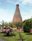
listed buildings. Nettlebed was the most important brick and tile making centre
in the Chilterns from the mid-14th century onwards. In 1365, 35,000 tiles were
made for Wallingford castle. One redundant lime burning kiln remains and is a
focal point of the village. Two pudding stones near the bus shelter are thought to be millions of years old and
were until recently outside the former Bull Hotel in the High Street and were used for mounting
horses.
There were several pubs in the village at one time but today there is only the
White Hart,
an old coaching inn now a hotel restaurant. Nettlebed Village Club
(formerly the Working men's Club) is a popular watering hole for the local
community. There is a thriving
post office/village shop. Brights of
Nettlebed have their headquarters here. The
Sue Ryder
Foundation have a palliative care home at Joyce Grove, former home of the
Fleming family.
The wonderful beech woods and hills
around make the village a popular start for walking and rambling.
Red Kites re-introduced to England in recent years can be seen regularly over
the village.
The countryside surrounding Nettlebed can offer some of the darkest skies in
this part of England. Binoculars and telescopes will amply reward the visiting
astronomer.